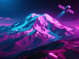
The NISAR satellite, a joint venture between NASA and the Indian Space Research Organisation (ISRO), has provided a remarkable view of Washington’s Mount Rainier. Captured on November 10, 2025, this image showcases the mountain’s features through the satellite’s advanced radar capabilities, even on a cloudy day.
Advanced Radar Technology
NISAR employs an L-band Synthetic Aperture Radar (SAR) instrument, which can penetrate cloud cover to reveal the surface below. The imagery from the NASA-ISRO Synthetic Aperture Radar mission displays various colors that indicate different surface characteristics. For example, areas highlighted in magenta reflect strong radar signals from flat surfaces such as roads and buildings, while yellow tones can arise from factors including land cover and moisture.
Interpreting the Imagery
The image features a spectrum of colors that provide insights into the region’s vegetation and land use. Yellow-green areas generally signify vegetation, such as the forests and wetlands surrounding Mount Rainier. In contrast, dark blue regions likely represent smooth surfaces, including vegetation-free clearings atop the mountain. Additionally, patches of purple squares near the mountain’s base indicate man-made alterations, possibly from forest thinning or regrowth.
NISAR’s Mission Parameters
Launched in July 2025 from the Satish Dhawan Space Centre in India, NISAR is equipped with the largest radar antenna reflector ever sent into space, measuring 39 feet (12 meters) in diameter. This innovative satellite carries two SAR instruments operating at different wavelengths, allowing it to monitor Earth’s land and ice surfaces with unprecedented frequency—twice every 12 days.
Collaboration and Future Insights
Managed by Caltech, the Jet Propulsion Laboratory (JPL) leads the U.S. component of the NISAR project, providing the L-band SAR and antenna reflector, while ISRO contributed the spacecraft bus and the S-band SAR. This collaboration aims to enhance our understanding of Earth’s dynamic systems and contribute to various scientific fields.
This article was produced by NeonPulse.today using human and AI-assisted editorial processes, based on publicly available information. Content may be edited for clarity and style.